
The KNVTS has a proud tradition to connect its vision on the future with a view on the historic past of shipbuilding practice. Time for the chair of the KNVTS Ship of the Year Committee Rien de Meij to take a step back and reflect on the idea of “vision”. Here is the story of “Three views on cartography”.
In Greece, the first attempts to describe geography date back to the sixth century BCE. Descriptions of the coastline and practical information about its circumnavigation were gathered in sailing directions [periplous], firstly in oral tradition, later in a written form [1]. The earliest record of the word periplous is found in The Histories of Herodotus, dated at the end of the fifth century BCE. He describes the routing of Darius’s Persian Fleet, in particular his fear for circumnavigating the harbourless coast of the peninsula of Athos.
In the first century CE, an unknown writer prepared a manuscript with sailing directions for the Red Sea [2]. Later, sailing directions for the Sea of Marmara were raised by Arrian of Nicomedia (active c130 CE), including distance tables [stadiasmos] for the various ports in that area, as well as sailing directions for the Black Sea [Periplous Euxeinou Pontou] [3].
Claudius Ptolemaeus
Cartography from that same period is by Claudius Ptolemaeus of Alexandria (87–150 CE). His approach included a system of orthogonal terms, being the coordinates of latitude and longitude. The advanced mathematical basis that was needed to accurately project spherical surfaces onto a flat surface, was suitable for large scale maps in the first place.
Ptolemaeus’ work Geographia was in the footsteps of Anaximander and Pythagoras (6th BCE), Parmenides (5th BCE), Aristotle (4th BCE), Eratosthenes (3rd BCE), Hipparchus and Polybius (2nd BCE), Poseidonius (1st BCE) and Strabo (1st CE). His maps were based on the now-lost atlas by Marinus of Tyre (active c. 100 CE) but renewed using additional Roman and Persian gazetteers and new principles [4].
Eventually the work of Ptolemaeus was lost for the western world, but copies found their way to the library of Baghdad where the books were preserved and translated into Arabic (9th CE). In that form, the manuscripts were rediscovered by Maximus Planudes (c. 1260 – c. 1305), a Byzantine Greek monk who translated the text into Latin and compiled the first new Ptolemean maps using the coordinates provided by that text [5].
Piri Reis
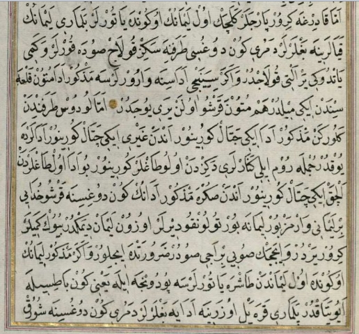
A glimpse of how the Byzantine world and the Western world were close, but separated, can be seen in the portolan charts of the Ottoman admiral and cartographer Piri Reis, first published in 1521 in the Kitab-i Bahriye (Book of Navigation) [6]. To produce his maps, Piri Reis combined his own observations with maps from the Islamic world and from the ancient period, or as he put it ‘Ískenderi Zülkarneyn zamanında’ (‘in the time of Alexander’). This made that the level of knowledge of plane geometry and trigonometry in these charts is much higher than in the early 16th century European charts.
The images below show his beautiful map of Odysseus’ Cephalonian Islands (rotated 180 degrees for north up) and a text passage describing the entry into a port on Kifelonya (Cephalonia), part of which has been translated by Svat Soucek in his paper on Islamic Charting in the Mediterranean [7]. An understanding of accuracy and uncertainty can be recognized in the fractal character of the coastlines and in the predetermined number of details per square mile.
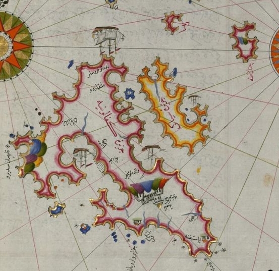
Portolan charts of Piri Reis: Ithaca.
Roman cartography
The Romans, instead, focused on detailed knowledge of the local topography at the frontiers of the provinces. They used schematic maps of the Roman road system, which detailed the distances between the settlements.
Roman seafaring was not very significant, as the Romans set to sea only when they could not avoid it [8]. The Roman Governors, the Legions, the traders and others preferred to travel over land, when underway to the provinces.
For cartography, the Romans followed their own methodology. Firstly, the Romans did not think in terms of physical geography, but in political geography. It was people rather than the land itself that submitted to Rome, and it was peoples, whether allies or provincials, who needed to be controlled and defended. The division into peoples was the relevant parameter and information about them could be as readily expressed in words as in maps.
Emperors in Rome distributed resources to each area of the empire and gave orders for any significant advance or withdrawal. The detailed implementation of these instructions was left to the provincial governors, who then reported what they had done [9]. This type of organisation and strategic planning firstly required functional information to support the logistic chain and secondly it required detailed topographical knowledge of the distant location.
For these reasons, the Roman preferred not to think in terms of latitude and longitude, but instead to work with schematic maps of the Roman state-run road [cursus publicus] which detailed the distances [milia passuum] between the settlements. The maps were not intended to guide off-road travel, but then no state official, officer in charge of any significant body of troops, or even an ordinary traveler would choose to do so [10].
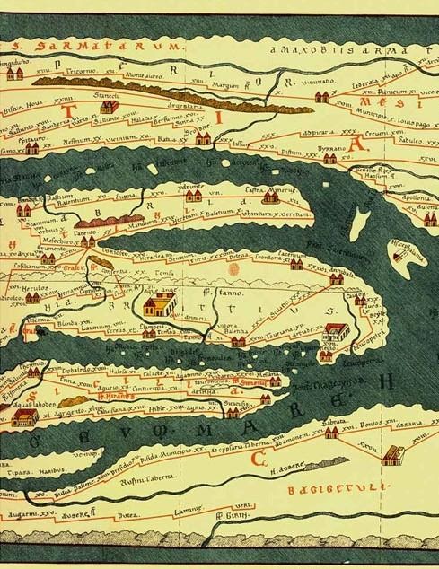
The best surviving example of such illustrated itinerarium, or ancient Roman road map, is the 4th century map now known as the Peutinger Map (Tabula Peutingeriana). The first idea for this type of map may have been based on a map that was prepared under the direction of Marcus Vipsanius Agrippa, a Roman general and architect, and friend and ally of Emperor Augustus. After Agrippa’s death in 12 BCE, the map was engraved in marble and put on display in a portico: the Porticus Vipsania in the Campus Agrippae area in Rome, close to the Ara Pacis building [11].
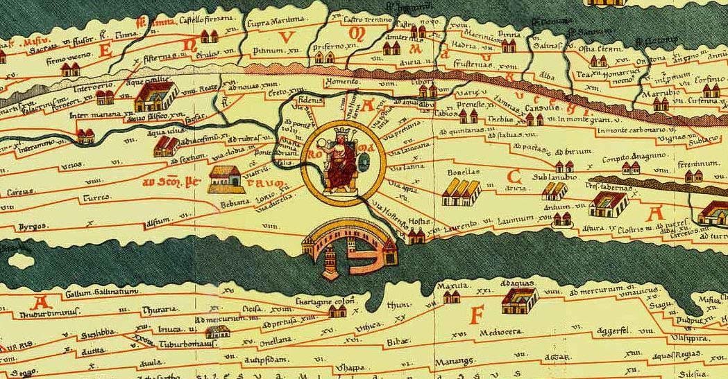
Tabula Peutingeriana (section I) [12].
We do not know, however, whether it was projected on a circle, schematic or oval, or, following the Ptolemaic fashion, in a terrestrial representation. The oldest known copy of the Map is dated 1265; a parchment rhapsody, measuring 0.34 m in height and 6.75 m in length. It is named after Konrad Peutinger (1465–1547), the Stadtschreiber (town clerk) of Augsburg, who brought it back to light and life, after it was found “somewhere in a library” by his friend Konrad Bickel in 1494 [13].
Tabula Peutingeriana (section II) [14].
Strategic planning
The absence of detailed maps does not suggest that there was no central strategic planning in the Roman Empire. In the contrary, the illustrated itineraria demonstrate that the pride of the Imperium, the network of roads, was designed to be functional; nothing better than this was needed to get the job done [15]. The long term effect, however, was that during the late empire, Roman scholars became further and further removed from the sources and knowledge of spherical cartography.
The lack of interest in the Ptolemaic approach was carried along into the Middle Ages. until it was rediscovered by Maximus Planudes (c. 1260 – c. 1305) – the Byzantine Greek monk who paved the way for new achievements.
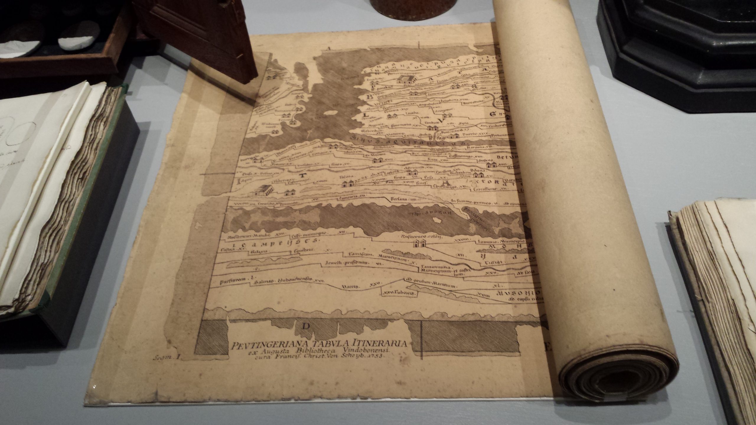
Picture (top): Tabula Peutingeriana: the Reuvens copy (1753) [16].
References
- The word periplous is derived from the words for navigation with a vessel [plous] around [peri] a sea.
- Periplus of the Erythraean Sea, written in Greek, anonymous.
- Sea of Marmara: as part of the ninth century codex Palatinus Heidelbergensis Graecus 398. Black Sea: as part of a report by Arrian as legatus Augusti propraetore Cappadociae to Emperor Hadrian.
- Bricker, C. 1968.
- Harley, J.B. Woodward, D. 1987. Montelle, C. 2011.
- The Piri Reis map is in the Library of the Topkapı Palace in Istanbul, Turkey.
- Soucek C. 1996.
- “Love the shore; let others keep to the deep sea”. [Virgil, Aeneid 5.163–4 (adapted)]
- Goldsworthy, A. 2016.
- Ibid.
- Webber, E. 1976.
- Top to bottom: Southern Italy, African Mediterranean coast (showing Rome as the seat of the crowned Emperor, and its harbor, and opposite of that Carthage).
- Webber E. 1976.
- Top to bottom: Dalmatian coast, Adriatic Sea, southern Italy, Sicily, African Mediterranean coast.
- Goldsworthy, A. 2016.
- Map at display at the Leiden National Museum of Antiquities.
 Series of articles
This is the eleventh in a series of articles written by Rien de Meij. An abbreviated version of this article was published in SWZ|Maritime’s December 2020 issue. The other articles are:
- “The theoretical ship” (also appeared in SWZ|Maritime’s January 2020 issue)
- “The modelled ship” (abbreviated version in SWZ|Maritime’s February issue)
- Navigare necesse est: To sail is necessary (abbreviated version in SWZ|Maritime’s March issue)
- The essential ship (abbreviated version in SWZ|Maritime’s April issue)
- The wine-dark sea (abbreviated version in SWZ|Maritime’s May issue)
- The lost ship (abbreviated version in SWZ|Maritime’s June issue)
- The sea battle of Artemision (abbreviated version in SWZ|Maritime’s July/August issue)
- The sea battle of Artemision | Part 2 (abbreviated version in SWZ|Maritime’s September issue)
- The battle of Salamis (abbreviated version in SWZ|Maritime’s October issue)
- Skylax of Caryanda (abbreviated version in SWZ|Maritime’s November issue)