The KNVTS has a proud tradition to connect its vision on the future with a view on the historic past of shipbuilding practice. Time for the chair of the KNVTS Ship of the Year Committee Rien de Meij to take a step back and reflect on the idea of “vision”. Here is the story of “Skylax of Caryanda”.
The Greek explorer Skylax of Caryanda travelled towards Gandhara. He sailed down the Indus River and then around the Arabian peninsula to reach Suez.
In the year 522 BCE, Darius I gained kingship of Persia. He would create an empire comparable to the Imperium Romanum. Quite soon after the start of his reign, he entrusts a Greek captain, Skylax of Caryanda, to do the reconnaissance for his Indian aspirations:
‘There is a river, Indus, second of all rivers in the production of crocodiles. Darius, desiring to know where this Indus empties into the sea, sent ships manned by Skylax, a man of Caryanda, and others whose word he trusted’
[1].
Caryanda is a small island off the coast of ancient Caria, quite near present-day Bodrum, Turkey. 19 kilometres to the south is Halicarnassus. 40 kilometres to the north is Miletus, which by the time of this story is a maritime empire with many colonies. The island, the town which lies on it, the bay which forms its harbour, and Skylax himself; they all carry that same name: Caryanda [2].
Skylax starts his journey by joining King Darius on his expedition towards Caspatyrus, a place somewhere in the valleys of the Kabul River, in the Satrapy of Gandara. Herodotus adds that this Satrapy belongs to the seventh and least profitable tax district of the Achaemenid Empire [3]. For Darius and Skylax, however, Caspatyrus was the door to a new world [4]. From here they would conquer the shores of the Indus River and explore the seas in which the Indus River empties.
Travelling the desert
The land surrounding Caspatyrus was a desert, full of unknown and strange creatures. Herodotus shares a wonderful story in which he describes a population of a large type of ants, not as big as dogs, but larger than foxes: ‘These ants live underground, digging out the sand… and the sand which they carry from the holes is full of gold’ [5].
The sand that contains gold is of such interest to the Indians, Herodotus tells us, that they ‘harness camels 3 apiece, males on each side… and a female in the middle: the man himself rides on the female, that when harnessed has been taken away from as young an offspring as may be. The Indians ride after the gold in teams, being careful to be engaged in taking it when the heat is greatest; for the ants are then out of sight underground.’
Herodotus goes on to explain:
‘So when the Indians come to the place with their sacks, they fill these with the sand and drive back as fast as possible; for the ants at once scent them out, the Persians say, and give chase. They say nothing is equal to them for speed, so that unless the Indians have a head start, while the ants were gathering, not one of them would get away. They cut loose the male trace-camels, which are slower than the females; … the mares never tire, for they remember the young that they have left. Such is the tale. Most of the gold (say the Persians) is got in this way by the Indians.’
[6]
River ships
Meanwhile Skylax and his companions do not stay in Caspatyrus too long but, for some 200 miles in easterly direction, they follow the downstream course of the Kabul River, nowadays a trickle of brown, muddy, water for most of the year. Close to the gorge where the Kabul River joins the Indus River, Skylax finds a place to build his river ships [8].
He then follows the course of the Indus River, moving southward. He and his companions serve as the reconnaissance team for the army of King Darius, who occupies the lands surrounding the Indus River. Around 516 BCE, Western India becomes the Achaemenid satrapy of Hinduš, referred to as “India” by the Greek writers [9]. Further to the east, but in the same period, Siddhārtha Gautama, “Buddha”, attains enlightenment and begins his ministry.
When Skylax finally reaches the 7 mouths of the river, he finds that only 1 of them, the 1 in the middle, is navigable; the others are shallow and marshy. By the shore is a settlement that later would become the market-town Krokola; the place where Alexander the Great prepared for his travel back to Babylon. Nowadays the place is called Karachi, a city with a population of 21 million people.

Map 1 – the Periplus of the Erythraean Sea (1597 CE) [10].
To the Persian Gulf
King Darius turns around and travels back to Persia. From there, he would move across the Hellespont, into Thrace (513 BCE). The Ionian Sea captain, however, continues his journey, exploring the coastline from the delta of the Indus to the Persian Gulf. Map 2 depicts the later route of the Cretan admiral Nearchos (red line), which approximates the route of Skylax, and of Alexander the Great (green line) [11].
The people who lived on the sandy strip between the Ommanitic desert and the crystal clear ocean would later be described by Nearchos as nomads and “fish-eaters” [ikhthuophagoi]. Much later, in the first century CE, this coast had small ports and market places that would host vessels underway from India to Arabia, shipping copper and sandalwood and timbers of teakwood and logs of blackwood and ebony, many pearls, clothing, wine, dates, gold and slaves [12].

Map 2 – The coastal route from the delta of the Indus to the Persian Gulf [13].
Eventually Skylax may have reached Bandar Abbas, an ancient corner stone for the trade between Euphrates and Western India.
Strait of Hormuz
Skylax, however, crosses the Strait of Hormuz and continues his voyage following the southwestern coastline of the Arabian Peninsula. He passes by the barren coast in which Asikh, Moskha, and Cani may have been settlements – with roadstead’s where ships could lie reasonably safe at anchor – of which the locals controlled the trade along the coast.
Finally, Skylax arrives at the southwestern tip of ancient Yemen. Its main port was called Eudaemon (“Prosperous”), now modern Aden. In Eudaemon all cargo from India and Egypt came together for transshipment, as nobody yet dared to sail from Egypt to India, or vice versa [14].
While staying close to the shore, Skylax passes through the eastern section of the sea strait which is named Bab-el-Mandeb, “Gate of Tears”, the section that would later be called “Bab Iskender”; Alexander’s Strait [15]. The trade across the Bab-el Mandeb was then controlled by the Sabaean kingdom and may have been the most dangerous part of his journey.
Egypt
We do not know whether he followed the coast of Arabia or that of the Berber [barbaroi] country, but steadily he moved north, in the tremendous heat and against the prevailing winds. Finally, he arrived at the Egyptian port of Mussel Harbour [Myos Hormos] near the entrance of the Gulf of Suez [16, 17].
Strabo mentions that, later, from this port sailed around a 120 ships to Arabia and India [18]. Here, Skylax may have ended his 30-month journey, in which he covered the 3200 miles that separate the delta of the Indus River from the northern part of the Red Sea.
Following the exploration of Skylax, King Darius commanded a canal to be excavated, providing access firstly to the Bitter Lakes and from there through the 50-km-long valley of the Wadi Tumilat towards Zagadis in the eastern Nile delta. He found that the sea was higher than the land, so he stopped making the canal, “lest the sea should mix with the river water and spoil it”.
From his port of arrival Skylax may have travelled overland to the Persian garrison in Memphis, to report and document his findings. His work, the Periplous of Skylax, is referred to by Hecataeus of Miletus when he wrote about the Indus Satrapies of the Achaemenides, and by Strabo, who refers to Skylax as an ancient writer [19].
Equal rights
If Skylax returned to Greece, then on the Acropolis he would find the building of the new temple in progress [20]. By 510 BCE, Cleisthenes, a member of the aristocratic Alcmaeonid clan, assumed leadership over Athens. He is credited with increasing the power of the Athenian citizens’ assembly [ekklēsia], and for reducing the power of the nobility over Athenian politics.
He installed isonomic institutions – equal rights for all citizens – and became the founding father of the Athenian democracy [democratia] [21]. The political structure of 48 wealthy ship-commissioners [naukraría] was replaced by a people’s assembly consisting of 50 demarchs [22]. A military organisation was established, consisting of 10 elected army leaders [strategoi], which stood under command of the archon polemarchos. This structure would hold till after the Persian Wars, about 478 BCE.
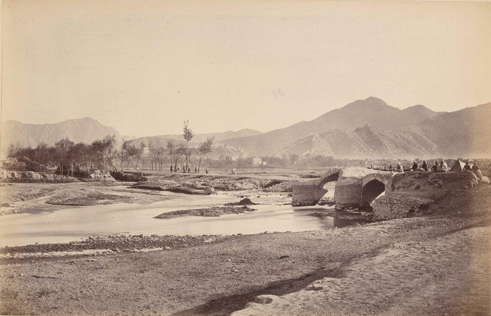
Picture (top): Kabul River, Old Bridge, with Bala Hissar in the Distance [7].
Acknowledgements
This story could only be formed thanks to the support of the online community for Classical Studies of The Center for Hellenic Studies, Harvard University. The story was earlier published under a Creative Commons Attribution-NonCommercial-NoDerivs 3.0 Unported license at https://kosmossociety.chs.harvard.edu/?p=46511. The images have been selected from pictures that are freely available with open source or Creative Commons licenses:
- Figure 1 – Kabul River, Old Bridge, with Bala Hissar in the Distance. Burke, J. 1878-1880 (photo). Public domain, via Wikimedia Commons.
- Map 1 – the Periplus of the Erythraean Sea (1597 CE). Abraham Ortelius. Map for the Periplus Maris Erythraei. Plate 162 from Theatrum orbus terrarum / Abraham Ortelius. Antverpiae: Apud Ioannem Bapt. Vrintium, 1609. Public domain via Wikimedia Commons.
- Map 2 – The coastal route from the delta of the Indus to the Persian Gulf. Detail from map titled Nearchos’ Voyage. S. Phalieros, Maios 1998, Chania. Map at display at in the Nautical Museum of Chania, Crete. Author (photo) Joke de Meij 2018.
References
- Herodotus, The Histories 4.44. The first river in terms of crocodiles [krokódeilos] was the River Nile.
- Strabo, Geography 14.2.20. “Caryanda, a harbor, and also an island bearing the same name, where the Caryandians lived. Here was born Skylax, the ancient historian”.
- Herodotus, The Histories 3.91.
- Caspatyrus is said to be probably Kabul”.
- Herodotus, The Histories 3.102.2.
- Herodotus, The Histories 3.105.1-105.2.
- Kabul River, Old Bridge, Bala Hissar in the distance. Burke, J. 1878-1880 (photo).
- Described in Herodotus, The Histories 3.100.
- In the spring of 480 BCE, Indian troops would march with Xerxes’ army across the Hellespont and fight for him in the Battle of Thermopylae [Herodotus, The Histories 7.65]. They became the first-ever force from India to fight on the continent of Europe.
- Abraham Ortelius. 1603. Map for the Periplus Maris Erythraei.
- Nearchos (c. 360 – 300 BCE) was one of the officers, a navarch, in the army of Alexander the Great. When Alexander reached the end of his expedition, he decided to return by sailing down the Hindu River and by circumnavigating the Indian peninsula. The Cretan Admiral Nearchos commanded the fleet of 150 ships with 14,000 men in a monumental voyage from Nikea to the Euphrates.
- The Greco-Roman periplus, the Períplous tē̂s Erythrâs Thalássēs, mentions the settlements of Ommana and Oraea.
- Map titled Nearchos’ Voyage. S. Phalieros, Maios 1998 Chania, at display at in the Nautical Museum of Chania, Crete. Photo by author.
- Strabo, Geography 2.5.12: “At any rate, when Gallus was prefect of Egypt, I accompanied him and ascended the Nile as far as Syene and the frontiers of Kingdom of Aksum (Ethiopia), and I learned that as many as one hundred and twenty vessels were sailing from Myos Hormos to India, whereas formerly, under the Ptolemy’s, only a very few ventured to undertake the voyage and to carry on traffic in Indian merchandise”.
- According to an Arabic legend, the Bab-el-Mandeb (Gate of Tears) derived its name from the numbers who were drowned by the earthquake which separated Asia and Africa.
- Berbers, or Barbaroi: “foreigners”; them speaking a tongue foreign to the ancient Greeks.
- Herodotus, The Histories 4.44 “…and voyaging over the sea west, they came in the thirtieth month to that place from which the Egyptian king sent the above-mentioned Phoenicians to sail around Libya“.
- Herodotus describes the length of the Red Sea as follows: “Now in Arabia, not far from Egypt, there is a gulf of the sea entering in from the sea called Red, of which the length is such as I shall show: for length, it is a forty days’ voyage for a ship rowed by oars from its inner end out to the wide sea”. [Herodotus, The Histories 2.11]
- Hec. fr. 179; F. H. G. i. 12 cited in How & Wells commentary on Herodotus 4.44. Strabo, Geography 14.2.20: “Skylax the ancient historian was a native of this island”.
- This temple was the Old Temple of Athena, the Archaios Neos, which would be destroyed in 480 BCE, during the destruction of Athens by the Persians.
- Isonomia; equality before the law. Derived from iso- + nómos, “law”. Democratia is “rule by the people”.
- Aristotle, school of, Athenian Constitution 21.5. Note that the number of ships, fifty, corresponds with the size of Athenian contingent that sailed to Troy. [Homeric Iliad 2.546-556]
 Series of articles
This is the tenth in a series of articles written by Rien de Meij. An abbreviated version of this article was published in SWZ|Maritime’s November 2020 issue. The other articles are:
- “The theoretical ship” (also appeared in SWZ|Maritime’s January 2020 issue)
- “The modelled ship” (abbreviated version in SWZ|Maritime’s February issue)
- Navigare necesse est: To sail is necessary (abbreviated version in SWZ|Maritime’s March issue)
- The essential ship (abbreviated version in SWZ|Maritime’s April issue)
- The wine-dark sea (abbreviated version in SWZ|Maritime’s May issue)
- The lost ship (abbreviated version in SWZ|Maritime’s June issue)
- The sea battle of Artemision (abbreviated version in SWZ|Maritime’s July/August issue)
- The sea battle of Artemision | Part 2 (abbreviated version in SWZ|Maritime’s September issue)
- The battle of Salamis (abbreviated version in SWZ|Maritime’s October issue)


