
(MARS 201875) A small bulk carrier was on passage at night with good visibility and fair weather. The vessel was following a track displayed on the ECDIS and was making good a course of 146º in autopilot steering at a speed of about 11 kt.
As edited from official UK Maritime Accident Investigation Branch (MAIB) report 22-2017
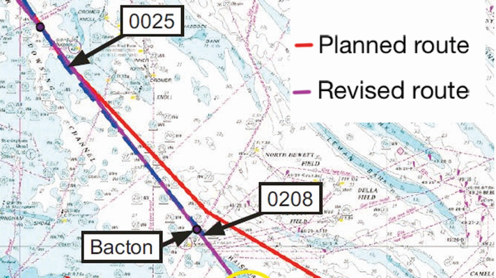
During the watch handover at midnight, the Master instructed the OOW to amend the passage plan to follow an alternative route. The OOW amended the passage plan on the ECDIS and adjusted the vessel’s heading on the autopilot to 140˚, following the revised track.
The OOW then sat in the starboard chair while the lookout alternated between standing on the bridge’s port side and sitting in the port chair.
The lookout routinely reset the bridge navigation watchkeeping alarm system (BNWAS). The vessel was 600m to the north-east of the revised track when the OOW adjusted the heading to 146º towards the waypoint "Happisburg" to the south of Haisborough Sand.
Vessel Runs Aground
About 40 minutes later, the OOW felt a change in the vessel’s motion. On seeing the speed reduce quickly, the OOW called the master. The master and chief engineer arrived on the bridge one minute later. Meanwhile, the OOW had zoomed in on the ECDIS display and changed the chart view display from "standard" to "all", which showed more detailed depth information. The master realised that the vessel was aground and put the engine telegraph control to stop.

It took five days to refloat the vessel, which subsequently had to be towed to port to repair a damaged rudder.
Some of the report’s findings include:
- The OOW’s visual check of the revised route did not identify that the track over Haisborough Sand was unsafe; it was neither planned nor checked on a chart of appropriate scale.
- The revision of the passage plan conflicted with the OOW’s watchkeeping duties and the master did not check and approve the revised route.
- The audible alarm and the guard zone had been disabled, removing the ECDIS barriers intended to alert bridge watchkeepers to imminent danger.
- The use of the ‘standard’ chart view limited the information displayed.
- Relying on visual checks when passage planning meant the process was prone to error.
- Lessons Learned
- Changing a passage plan "on the fly", in this case at night, while underway and without the master’s final check, introduces additional risks.
- Select the appropriate level of zoom and chart view when using ECDIS, especially when navigating coastal waters.
Editor’s Note
While ECDIS is undoubtedly a leap forward in continuous situational awareness when compared with paper charts, like any tool it must be used appropriately. The ease with which a route can be changed should not relieve the mariner of the need to verify that the route is actually safe for their vessel.
MARS Reports
This is one of the December MARS Reports that are part of Report Number 314. A selection of this Report has also been published in SWZ|Maritime’s January issue.
Acknowledgement
Through the kind intermediary of The Nautical Institute we gratefully acknowledge sponsorship provided by:
American Bureau of Shipping, AR Brink & Associates, Britannia P&I Club, Cargill, Class NK, DNV, Gard, IHS Fairplay Safety at Sea International, International Institute of Marine Surveying, Lairdside Maritime Centre, London Offshore Consultants, MOL Tankship Management (Europe) Ltd, Noble Denton, North of England P&I Club, Sail Training International, Shipowners Club, The Marine Society and Sea Cadets, The Swedish Club, UK Hydrographic Office, West of England P&I Club
Submit a Mars Report
More reports are needed to keep the scheme interesting and informative. All reports are read only by the Mars coordinator and are treated in the strictest confidence. To submit a report, please use the Mars report form and send it to mars@nautinst.org.